2223 E. Ocean, Long Beach, CA 90803
3 Beds
3 Baths
$2,097,000
2223 E. Ocean, Long Beach, CA 90803
3 Beds
3 Baths
$2,097,000
2223 E. Ocean, Long Beach, CA 90803
3 Beds
3 Baths
$2,097,000
2223 E. Ocean, Long Beach, CA 90803
3 Beds
3 Baths
$2,097,000
2223 E. Ocean, Long Beach, CA 90803
3 Beds
3 Baths
$2,097,000
2223 E. Ocean, Long Beach, CA 90803
3 Beds
3 Baths
$2,097,000
Rancho Palos Verdes Homes for Sale
You can find the best Rancho Palos Verdes real estate listings by browsing the listings below. Whether you’re looking for a comfortable house or a luxurious condominium in Rancho Palos Verdes, you’ll find the best home for you and your family. When you find a couple of your favorite Rancho Palos Verdes homes for sale, contact us to begin your buying journey. As the leading realtors in the Palos Verdes Peninsula we’ve helped hundreds of families buy their new home.
Rancho Palos Verdes Real Estate Market
|
Average Home Sale Price: |
$1,845,000 |
|
Sale Price Per Sq. Ft: |
$1,845,000 |
|
Sale Price Per Sq. Ft. (% Change from last year): |
(14%) |
|
Number of Homes Sold |
113 |
|
Number of Homes Sold (% Change from last year) |
2% |
|
Months Inventory: |
1 |
Three Months ending September 2020
Rancho Palos Verdes is one of the most beautiful cities in the world to live. The Palos Verdes Peninsula is also one of the wealthiest communities in the country, as described in the Los Angeles Business Journal. This unique city has an interesting history and was founded on the principle of maintaining the low density of development which was being threatened, and preserving as much of the beautiful open space as possible, which made it such a unique community. Rancho Palos Verdes consists of 13.5 square miles, with 7.5 miles of coastline. The city is the largest city on the Palos Verdes Peninsula.
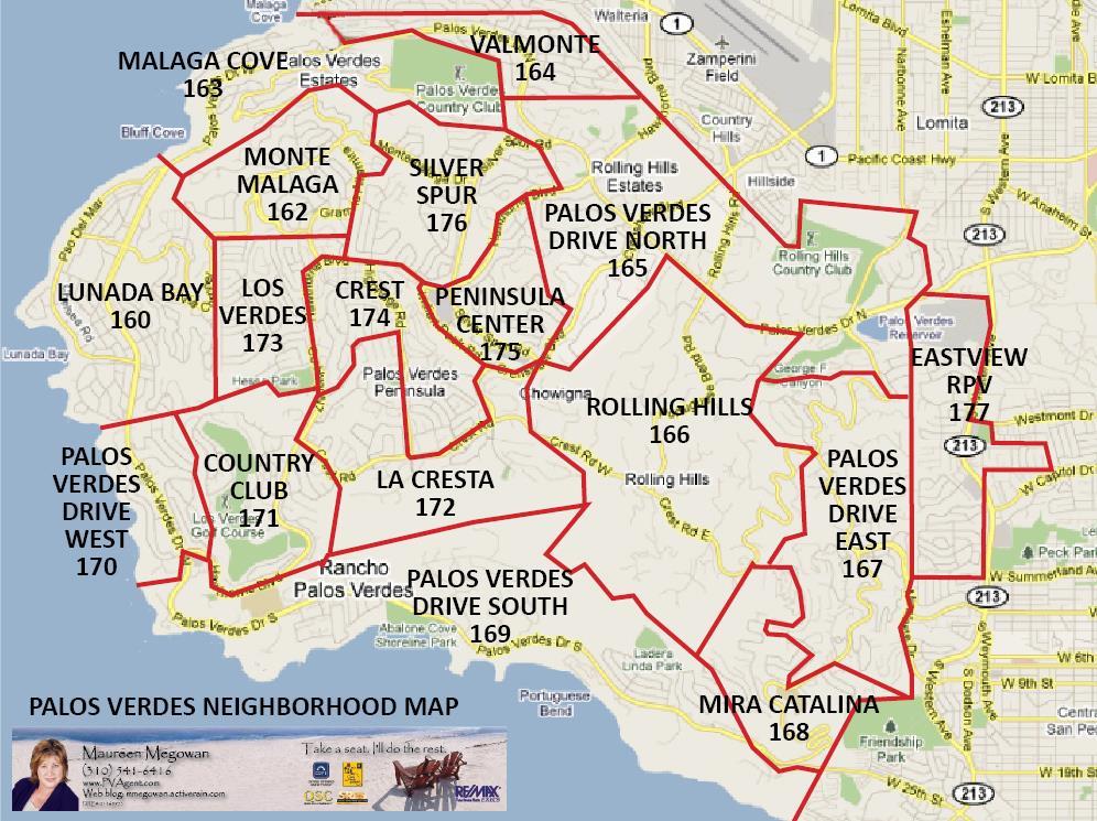
Refer to this map of Palos Verdes for the below information.
Palos Verdes Drive East (Miraleste): (Area 167 in map above) This neighborhood on the eastern side of the Palos Verdes Peninsula is bordered by the City of Rolling Hills on the west, the Eastview area to the east, and the Mira Catalina area to the south (south of Crest Road). Although many of the homes here have large lots, the steep terrain restricts the useability of many yards. Many of the homes in this area have city and Harbor views. Palos Verdes Drive East is the main road through the center of the neighborhood. Many of the lots in this area are zoned for horses. Neighborhoods include Miraleste Hills, Colt Road, Coach Road, Bronco, Sunnyside Ridge, Rockinghorse and Roan Road.
Mira Catalina:( Area 168 in map above) This area is between the Miraleste area and the Palos Verdes Drive South area, and is primarily accessed by the southern portion of Palos Verdes Drive East (south of Crest Road) until it ends at Palos Verdes Drive South. Many homes in this area enjoy spectacular views of the ocean and Catalina Island. Marymont College is located in the Mira Catalina neighborhood.
Palos Verdes Drive South: (Area 169 in map above) This neighborhood stretches along the coastline from the border of San Pedro along Palos Verdes Drive South, including the Portuguese Bend area, north to Point Vicente Park and the western terminus of Hawthorne Boulevard. Palos Verdes Drive South is the principal road serving this area. Many of the homes in this area offer excellent ocean and Catalina views. The Portuguese Bend Club is in the center of this portion of the Peninsula, and is adjacent to the Portuguese Bend landslide moratorium area. Homes in the landslide area have restrictions on their ability to be expanded or renovated. The nearest shopping area for homes in the southern portion of this neighborhood is located in San Pedro. Golden Cove Center is located at the northern end at the intersection of Palos Verdes Drive South and Hawthorne and contains the Admiral Risty Restaurant, a Trader Joes market, a Montessori school, and many local services. The Wayfarers Chapel is also located in this area. Other neighborhoods include Abalone Cove, Ladera Linda, Vista Pacifica, Seacove, and Seabluff.
Several condominium and townhouse projects are located in this area including the Ocean Terrace condominium project adjacent to the newly completed Trump National Golf Course at the southern end of the area, the Palos Verdes Bay Club condominiums and the Seahill and Coastsite townhomes, located just south of the new Terranea resort (formerly Marineland/Long Point), and the Villa Capri townhomes located adjacent to the Golden Cove shopping center..
West Palos Verdes:( Area 170 in map above) This area is just south of Palos Verdes Estates, and stretches south along the coastline along Palos Verdes Drive West to Hawthorne Boulevard. This area includes new luxury home developments such as Ocean Front Estates at the southern terminus of Hawthorne Boulevard. Many homes in this area enjoy excellent ocean and Catalina Island views. Neighborhoods include Lunada Pointe (adjacent to Palos Verdes Estates), Berry Hill, Point Vicente, Warmington Estates, and Oceanfront Estates.There are no condominium developments in this neighborhood.
Country Club: (Area 171 in map above) This area surrounds the Los Verdes Golf Course as well as an area to the east of Hawthorne Boulevard and south of Crest Road. The area below Hawthorne Boulevard and Crest Road is known as Monte Verde, and the area to the east of Hawthorne Boulevard is known as the the Monaco area. Other neighborhoods include Alta Vista, Condo and townhome developments in this area include Seagate and the Island View condos.The only commercial development in this area is a Ralphs Supermarket, which services the entire west side of Rancho Palos Verdes.
La Cresta: (Area 172 in map above)This is a neighborhood with about half of the homes located in Rancho Palos Verdes (south of Crest Road just west of Rolling Hills, and the area to the east of Crenshaw Boulevard north of Crest to Silver Spur Road, as well as the Wallace Ranch Project at the intersection of Armaga Springs Road and Highridge Road), and most of the rest of the homes in this area are located in Rolling Hills Estates (in the area north of Crest road bordered by Hawthorne Blvd, Indian Valley Road and Highridge roads ). Many of the homes in this area are in newer developments such as Island View homes, Wallace Ranch, The Ranch as well as other neighborhoods such as Del Cerro.
Los Verdes: (Area 173 in map above) This neighborhood is west of Hawthorne Blvd., south of Silver Spur Road, and north of Hess Park. The homes in this area are all single family residences, and terrace down the west side of the Peninsula, thus many of the homes have views.
Crest: (Area 174 in map above) This area is in the center of the Palos Verdes Peninsula and is bordered by Hawthorne Blvd on the east, Indian Valley and Armaga Springs roads on the south, Indian Peak road and Crenshaw Blvd on the east, Crest road on the south, and the area to the east of Highridge Road (south of Highridge Park and Armaga Springs Road, and north of Crest Road). Most of this area is located in the City of Rancho Palos Verdes, but about 20% is located in the City of Rolling Hills Estates (including The Terraces project and the homes immediately on the east side of Highridge south of the Terraces project to Crest Road). Due to its location, most homes in this area do not have views. The homes in this area are primarily townhomes and condominium developments including the Ridgegate, Mira Verde, Armaga Spring and Hilltop Circle townhome developments, as well as a number of condominium buildings on Ravenspur Drive as well as condominiums on Peacock Ridge. This area has the highest concentration of multi-family units on the Peninsula.
Peninsula Center: (Area 175 in map above) This neighborhood is immediately north of the Peninsula Center shopping district and is bordered by Hawthorne Boulevard and Silver Spur Road. A neighborhood at the northern part of this area is called the Blackhorse area and contains homes that are larger, newer and more expensive than the homes closer to Silver Spur Road. The area has three shopping areas, actually located in the City of Rolling Hills Estates, including the Avenue of the Peninsula, the Peninsula Center, and the Town and Country Shopping Center, which are all located to the south of Silver Spur Road. This neighborhood includes the commercial heart of the Peninsula. The Promenade of the Peninsula is a three level open air mall featuring a skating rink, movie theaters, restaurants, and shops. The other two shopping centers feature grocery stores, drug stores, and other shops. The main Public Library as well as the main Peninsula Post Office is located on Deep Valley Road, This road has a “village” feel to it, with several excellent restaurants, and several new developments are planned for the near future, including new office and senior housing (see below). The Mall and other shopping centers and commercial areas bordered by Silver Spur Road between Hawthorne Blvd. and Crenshaw and Indian Peak Road are all within the boundaries of the City of Rolling Hills Estates. Silver Spur Road is the main road servicing this area, and includes most of the office development in the City. The Norris Center for the Performing Arts is also located here. The Norris presents many excellent plays and musicals during the entire year, several of which are local productions.
Silver Spur: (Area 176 in map above) This area includes homes off of Silver Spur Road to the north of Hawthorne Boulevard until Montemalaga Drive, the borders of the city of Palos Verdes Estates on the north and west, and Hawthorne Blvd on the South.The homes in this area tend to be smaller and older than many of the other homes in Rancho Palos Verdes, and therefore tend to be more affordable. Neighborhoods include Grandview Estates. Peninsula High School is located in this area. Most of this area is located in the city of Rancho Palos Verdes except for Peninsula High School and some homes to the east of Silver Spur Road just before Montemalaga that are located in the City of Rolling Hills Estates.
Eastview: (Area 177 in above map) This neighborhood is directly west of San Pedro at the eastern base of the Palos Verdes Peninsula and is generally bordered on the east by Western Avenue, except for a small area which extends east of Western Avenue along Toscanini Drive. Many of the homes in this area are only accessible from Western Avenue. Most of the homes in this area have an option of students either attending the Palos Verdes School District or the Los Angeles Unified School District (see below).
Students generally attend school at Palos Verdes Peninsula High School (located in Rolling Hills Estates) , Ridgecrest Intermediate School and Miraleste Intermediate School, and several local elementary schools, all part of the Palos Verdes Unified School System. There is an additional high school located in Palos Verdes Estates, Palos Verdes High, and both high schools are California Distinguished Schools, with open enrollment to students on the Peninsula (they do not have enrollment boundaries). Palos Verdes High has a unique class scheduling structure, called block scheduling, where students attend three extended periods each day, alternating with their other three classes each day. Peninsula High has a more traditional structure of the same periods for all classes each day.
Those students who live in the Eastview area (Area 88 in the boundary matrix at Attendance Boundaries) have a one-time election to enroll in either the Palos Verdes School District ( attending Dapplygray Elementary and Miraleste Intermediate ), or the Los Angeles Unified School District (Dodson Middle School and Crestwood Elementary School). Those living in the Eastview area do not pay the bonded indebtedness on their property tax bills ( 2009/2010 of $21.64 per $100,000 valuation ) for the Palos Verdes School District, but instead are billed for the Los Angeles Unified School District bonded indebtedness on their property tax bills (2009/2010 of $151 per $100,000 valuation). Eastview residents vote only on School Board elections for Los Angeles Unified Schools regardless of whether they have elected to attend the Palos Verdes School District.
PVUSD has some of the highest test scores in the state. There are also a number of excellent private schools on the Palos Verdes Peninsula.
Most of the cultural activities for the city are located in Rolling Hills Estates, adjacent to Rancho Palos Verdes. These include the Norris Center for the Performing Arts, the Peninsula Symphony, and the PV Players. The Palos Verdes Art Center is located in the City of Rancho Palos Verdes. For further information on Arts and Culture on the Peninsula, Click Here.
Children play baseball in three little leagues ; Rolling Hills Little League (located in adjacent Rolling Hills), Silver Spur Little Leage (located in adjacent Rolling Hills Estates), and the Lunada Bay Little League ( located in the adjacent Palos Verdes Estates) , (For a map of the little league boundaries, Click Here) Pony League baseball for 13 to 15 year olds, is available at Ernie Howlett park in Rolling Hills Estates, and George Allen Field in Palos Verdes Estates. AYSO Soccer leagues are active throughout the City. Girls softball is generally played on fields at various school locations There are also youth basketball leagues, and lacrosse leagues for intermediate schools.
Public Golf Facilities are available at Los Verdes Country Club. Los Verdes is a public golf course run by the County of Los Angeles. Trump National Golf Club is a public course which is planned to open in December 2005, and is located at the southern edge of Rancho Palos Verdes adjacent to San Pedro. There is also a 9 hoe golf course at the new Terranea Resort. See Golf on the Palos Verdes Peninsula for detailed information and critiques of the Golf courses on the Palos Verdes Peninsula.
Rancho Palos Verdes has several large parks including Hesse Park and Ryan Park. Hesse Park, located on Hawthorne Boulevard, has 29 acres, 2 softball diamonds, soccer fields, running track, children’s play area, community room, and restrooms. Hesse park is also where the City Council and Planning Commission holds its public meetings. See Rancho Palos Verdes Parks for a map and description of the various city parks.
Ryan Park, located south of Hesse Park on Hawthorne Boulevard consists of 10 acres, a baseball field, grass areas, children’s play area, and restrooms. Del Cerro Park, located at the end of Crenshaw Boulevard, south of Crest Road, is a 5 acre park, with no facilities, Abalone Cove Shoreline Park, located near Portuguese Bend off of Palos Verdes Drive West, has picnic tables and beach access.
Equestrian facilities are located in the City at the Portuguese Bend Riding Club, as well as the Palos Verdes Stables in Palos Verdes Estates, and Ernie Howlett Park in Rolling Hills Estates. Private riding facilities are also available in Rolling Hills Estates.
Tennis may be played at the Peninsula Racquet Club, Ernie Howlett Park in Rolling Hills Estates, the Jack Kramer Club in Rolling Hills Estates, or at one of the excellent courts at Peninsula High. Tennis League play is available through the South Bay Marine League, which has teams at most of the private tennis clubs in the area as well as Ernie Howlett Park in Rolling Hills Estates
Point Vicente Interpretive Center is located near the southern terminus of Hawthorne Boulevard, just south on Palos Verdes Drive West. This Center is one of the best viewing points for the semiannual migration of whales along the California coast. The center was recently expanded and remodeled.
There are numerous hiking trails in the city, particularly at the Martingale Trailhead Park. The Palos Verdes Land Conservancy also conducts periodic nature walks.
For additional information about sports, parks and recreation opportunities on the Peninsula, click here.
Property Taxes:
The Rancho Palos Verdes property tax rate for the fiscal year 2024-2025 is 1.081089% plus direct assessments of approx. $900-$1,100 per parcel for such items as school parcel taxes, etc., and a storm drain user fee which is based on the amount of runoff to the sewer system that a property generates, that for an average size lot is approx. $90 per year.
Property Taxes in the South Bay of Los Angeles County are computed by the standard 1.0% of the property’s assessed valuation (in accordance with Proposition 13, a property’s assessed valuation is the original purchase price, plus the cost of improvements, based on the value of permits pulled, plus an increase in valuation of 2% per year) plus additional tax rates for voted bonded indebtedness, plus direct assessments such as school parcel taxes.
Taxes are assessed for the fiscal year running from July 1st through June 30th, with property tax bills payable in two installments on December 10th and April 10th. If a property changes ownership during the year, a supplemental tax bill will be prepared prorating the tax increase due to a change in valuation over the remainder of the fiscal year. If a change in ownership occurs between January 1 and May 31 this will result in two supplemental assessments and two supplemental tax bills. The first supplemental bill is for the remainder of the fiscal year in which the event occurred. The second supplemental bill is for the subsequent fiscal year.
Utility Tax: The City charges a utility tax on all utility bills (water, gas, electric and telephone bills) of 3%.
Property Transfer Tax: The County of Los Angeles and the City levies a transfer tax upon the sale of a property totaling $1.10 per thousand dollars of the sale price.
Police, Fire and Paramedic services are contracted with Los Angeles County with the Los Angeles Sheriff’s Department, and the Los Angeles County Fire Department.
The following places of worship are located in Rancho Palos Verdes:
- Ascension Lutheran Church- 26231 Silver Spur Rd,
- Chabad Of Palos Verdes- 28041 Hawthorne Blvd,
- Church Of Jesus Christ Of Lds – 5845 Crestridge Rd,
- Community Christian Church – 1903 W Summerland St,
- Congregation Ner Tamid- 5721 Crestridge Rd,
- Wayfarers Chapel (The Glass Church) – 5755 Palos Verdes Dr S,
- Mt Olive Lutheran Church – 5975 Armaga Spring Rd,
- Pacific Unitarian Church – 5621 Montemalaga Dr,
- Peninsula Baptist Church – 5640 Crestridge Rd,
- Peninsula Community Church – 5640 Crestridge Rd,
- Shri Satya Sai Bab Spirital – 6869 Verde Ridge Rd,
- South Bay Evangelical Church – 5640 Crestridge Rd,
- St John Fisher Catholic Church – 5448 Crest Rd, (intersection of Crenshaw)
- St Paul’s Lutheran Church – 31290 Palos Verdes Dr W,
- St Peter’s Presbyterian Church – 6410 Palos Verdes Dr S,
Population in July 2016: 42,726. Population change since 2000: +3.8%
Males: 20,214 (47.3%), Females: 22,512 (52.7%)
Elevation: 653 feet
County: Los Angeles
Land area: 13.7 square miles
Zip code: 90275
Median resident age: 50.0 years
Median household income: $127,718
Crime in Rancho Palos Verdes (2017)
- 0 murder ( 0 per 100,000)
- 5 rapes ( 18.3 per 100,000)
- 7 robberies (14.0 per 100,000)
- 21 assaults (32.6 per 100,000)
- 152 burglaries (274.8 per 100,000)
- 35 auto thefts (76.8 per 100,000)
City-data.com crime index (2017)= 80.1 (higher means more crime, US average = 280.5)
For population 25 years and over in Rancho Palos Verdes:
- High school or higher: 97.0%
- Bachelor’s degree or higher: 65.2%
- Graduate or professional degree: 31.1%
- Unemployed: 2.6%
- Mean travel time to work (commute): 30.6 minutes
Ready to buy?
Thank you for visiting maureenmegowan.com!
This is a one-stop real estate website for all your home buying and selling needs in the South Bay and Palos Verdes Peninsula.
We will help make your search for a new home an enjoyable experience.
Please feel free to contact us if you have any questions about the market, or buying or selling a home.