The Best Hiking Trails on the Palos Verdes Peninsula
The Palos Verdes Peninsula offers some of the best hiking trails in all of Southern California. The Peninsula eons ago was underwater, and as it rose out of the ocean a terraced landscape was created with tall hillsides with magnificent city and ocean views. The developers of the equestrian cities of Rolling Hills Estates and Rolling Hills, the master planned community of Palos Verdes Estates and the city of Rancho Palos Verdes had the foresight to set aside parklands in their natural state for the many future generations to enjoy. The Palos Verdes Peninsula Land Conservancy has also created several large nature preserves laced with numerous hiking trails. The Palos Verdes Trail Map includes the following hiking trails:
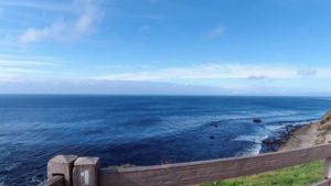
- Ocean Trails Reserve – These trails begin below the Trump national golf course on either side of Founders Park. One goes down to the beach (Sunset Trail) where you can bring your dog but legally you must have the dog on a leash but this has been a hide-away off-leash dog beach for many years. This is a rather steep trail. Enter trail below the club house on the right. There is public access parking before you get to the clubhouse. Another trail starting on the east side of Founders Park below and to the left of the clubhouse goes along the ocean side bluffs next to the golf course called the “Catalina Trail”. This trail goes all the way down to below the Ocean Terrace condo project to the border between Rancho Palos Verdes and San Pedro
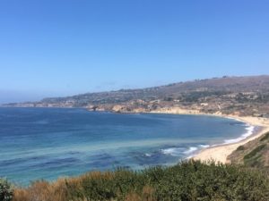
View of northern side of Ocean Trails Reserve
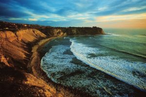
- Ocean Trails Reserve South – Located at the bottom of La Rotonda Drive just south of the Trump National Golf course. There is free parking. Lakeview trail begins at the north end of the parking lot and leads to the Catalina Trail and access to an easy trail to the beach to the north and along the ocean side bluffs adjacent to the golf course or to the south to several trails past the Ocean Terrance condos. Dogs need to be on a leash.
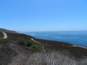
View of Southern portion of Ocean Trails Reserve
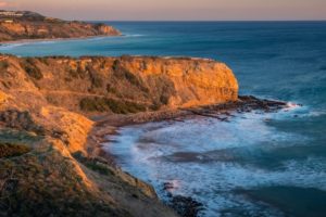
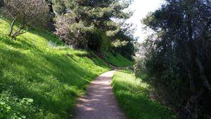
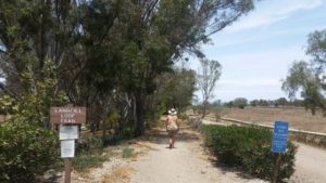
- Forrestal Nature Reserve – This 155 acre preserve is above the Trump National golf course and parking is available at the Ladera Linda Community Center, 32201 Forrestal Drive, Rancho Palos Verdes.

Fprrestal Nature Reserve
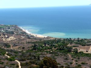
- Abalone Cove Trail– These trails lead to two beaches (Abalone Cove and Sacred Cove) with trails that crisscross the area. Paid parking is available at Abalone Cove Shoreline Park south of the Terranea Resort and just north of the Portuguese Bend area. Swimming in the water at Sacred Cove can be very dangerous so beware. These trails offer access to incredible tide pools at low tide and great Catalina and ocean views.
Abalone Cove Shoreline Park
- Portuguese Bend nature preserve – Numerous trails offering spectacular canyon and ocean trails may be accessed from the Trail Head near the southern end of Crenshaw Blvd in Rancho Palos Verdes just before the Del Cerro park or at the very end of Crenshaw. Beware of parking restrictions. These trails include the Burma Road trail that starts at the end of Crenshaw offering access to trails to the south that go all the way to Palos Verdes South or start from the Trail Head down the Rattlesnake Trail to trails to the north side of the Portuguese Bend Reserve to the Filorium Reserve above the Vanderlip estate and the Three Sisters Reserve.
View from Del Cerro Park of Portuguese Bend Nature Reserve
- Rancho Palos Verdes City Hall -This trail offers a loop of trails overlooking the Point Vicente lighthouse and the Terranea Resort. These trails can be accessed from the end of Point Vicente Park adjacent to the RPV City hall. You can also see the remains of the Nike missile site and bunkers from WW II
- Seascape trail – This trail goes along the ocean bluffs below the Ocean Front Estates luxury home area at the southern end of Hawthorne Blvd in Rancho Palos Verdes at 31501 Palos Verdes Dr W, Rancho Palos Verdes, CA 90275. There are trail access points at several spots along Calle Entradero.
View from Seascape Trail
- Lunada Bay – The Lunada Canyon trail begins at the intersection of Paseo Lunado and Via Rivera in the Lunada Bay area of Palos Verdes estates and travels the length of Lunada Canyon up towards Hawthorne Blvd. There are also several ocean bluff top trails and parklands along the northern and southern ends of Paseo del Mar. The southern end of Paseo del Mar is accessed by the southern side of Paseo Lunado past the elementary school and the northern piece of Paseo del Mar (accessed by the north side of Paseo Lunado on the northern side of Lunada canyon). This piece of Paseo del Mar (2316 Paseo del Mar, Palos Verdes Estates) overlooks Lunada Bay, a spectacular Bay with beautiful ocean and Catalina views as well as the Blufftop trail at the northern end of Paseo del Mar overlooking Bluff Cove with incredible views of the Santa Monica Bay.
Lunada Bay
- Palos Verdes Estates Trails – There are several interesting trails in Palos Verdes Estates. The first is the Apsley trail at the northern end of the Lunada Bay area which goes up the hill and turns into the Palos Verdes Loop trail which can also be accessed at the upper end of the trail at the left side of1821 Paseo Del Sol. Another trail is the Lower La Dosta Fire Station trail and the Upper La Costa Fire trail road in the Malaga Cove area. This trail can be accessed across the street from the back side of the park next to the Palos Verdes Estates city hall. There are also trails in the median strip of Palos Verdes Drive West through both the Lunada Bay area as well as the Valmonte area north of Malaga Cove Plaza lined with eucalyptus trees.
La Costa Trail in Malaga Cove , Palos Verdes Estates
Another interesting trail is the Valmonte Canyon Trail which has trails on either side of the canyon located at the intersection of Palos Verdes Drive North and Via Opata or the Fern Creek trail on the eastern side of Palos Verdes Dr. North between Ponderosa Lane and Via Campesina that loops around to join the Valmonte Canyon Trail. The Valmonte Canyon trail also has a spur to the east that offers access to the Ernie Howlett Park in Rolling Hills Estates. At the start of the Fern Creek Trail is the Bridle Trail that goes south on both side of Palos Verdes Drive North all the way to just past the /rolling Hills Covenant Church where it connects to the Carriage Trail that loops back the Palos Verdes Drive East.
Valmonte Canyon Trail
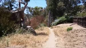
- Landfill Loop Trail – This trail which begins from the Peter Weber Equestrian Center off of Crenshaw Blvd. and extends around the Palos Verdes landfill site between Crenshaw and Hawthorne in Rolling Hills Estates.
Palos Verdes Landfill trail
- George F Canyon Nature Center and Preserve – This trail located just south of Palos Drive North on Palos Verdes Drive East extends the length of the Preserve.

George F Canyon Nature Preserve
- Martingale Trailhead Park – This canyon trail connects to the Lower Willow Springs Trail that goes both north to a system of trails within Rolling Hills and also to the south where it connects to Upper Willow Springs trail . Located at 21 Martingale Dr. Rancho Palos Verdes
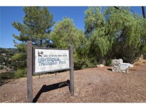
Martingale Trailhead park
You could hike for years and not traverse all of the multitude of trails that intertwine throughout the Palos Verdes Peninsula, a true rural oasis in the middle of Southern California.